 Catalogue PIGMA
/Remote sensing
Type of resources
Available actions
Topics
Keywords
Contact for the resource
Provided by
Years
Formats
Representation types
Update frequencies
status
Scale
Resolution
-
Monomission altimeter satellite along-track sea surface heights computed with respect to a twenty-year mean. Previously distributed by Aviso+, no change in the scientific content. All the missions are homogenized with respect to a reference mission which is currently OSTM/Jason-2. The sla is computed with an optimal and centered computation time window (6 weeks before and after the date). Two kinds of datasets are proposed: filtered (nominal dataset) and unfiltered.
-
Ocean-surface optical parameters: reflectances
-
Multimission altimeter satellite gridded sea surface heights and derived variables computed with respect to a twenty-year mean. Previously distributed by Aviso+, no change in the scientific content. All the missions are homogenized with respect to a reference mission. The acquisition of various altimeter data is a few days at most. The sla is computed with a non-centered computation time window (6 weeks before the date).
-
Along-track altimetric GDR (Geophysical Data Record) products , geophysical and environmental corrections to apply. Available missions are: GFO, Topex/Poseidon, Envisat, Cryosat-2, Jason-1, Jason-2, Jason-3, Saral/AltiKa. Missions with several successive orbital types are treated in their entirety. Compared to the original version of the GDR files distributed by the CNES, ESA, NASA and ISRO agencies, the CTOH proposes new corrections and parameters in these files, which are to be applied to the initial altimetry measurement, according to user needs. Children metadata files are available for each mission.
-
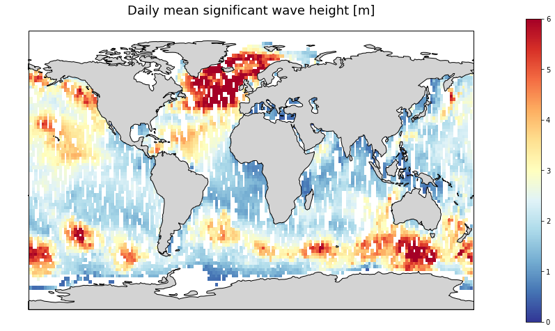
Gridded multi-mission merged satellite significant wave height in Near-Real-Time. It merges along-track SWH data from the following missions: Jason-3, Sentinel-3A, Sentinel-3B, SARAL/AltiKa, Cryosat-2 and CFOSAT.
-
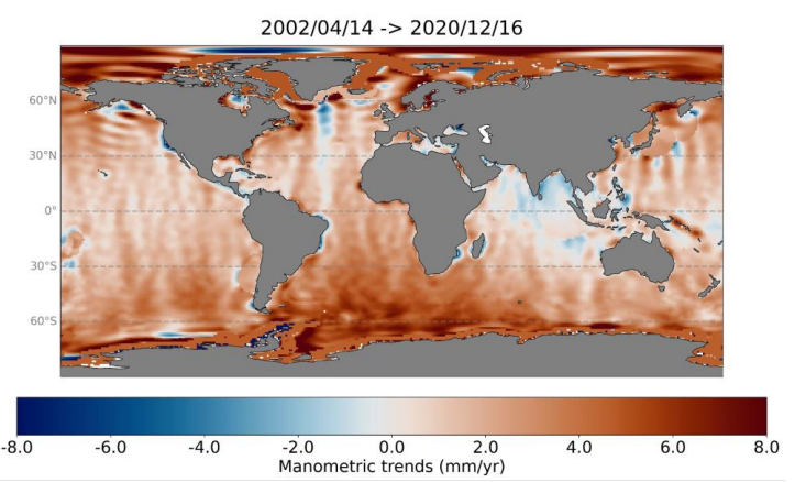
Barystatic and manometric sea level changes represent the mass component of sea level changes at global and regional scales respectively. Barystatic and manometric sea level changes are estimated here using the satellite gravimetry measurements from the GRACE and GRACE-FO missions. Two products are distributed over the April 2002 to August 2022 period: - Barystatic sea level changes from satellite gravimetry with uncertainties at 1-sigma: monthly time series, - Manometric sea level changes from satellite gravimetry with uncertainties at 1-sigma: monthly grids with 1x1 degree.
-
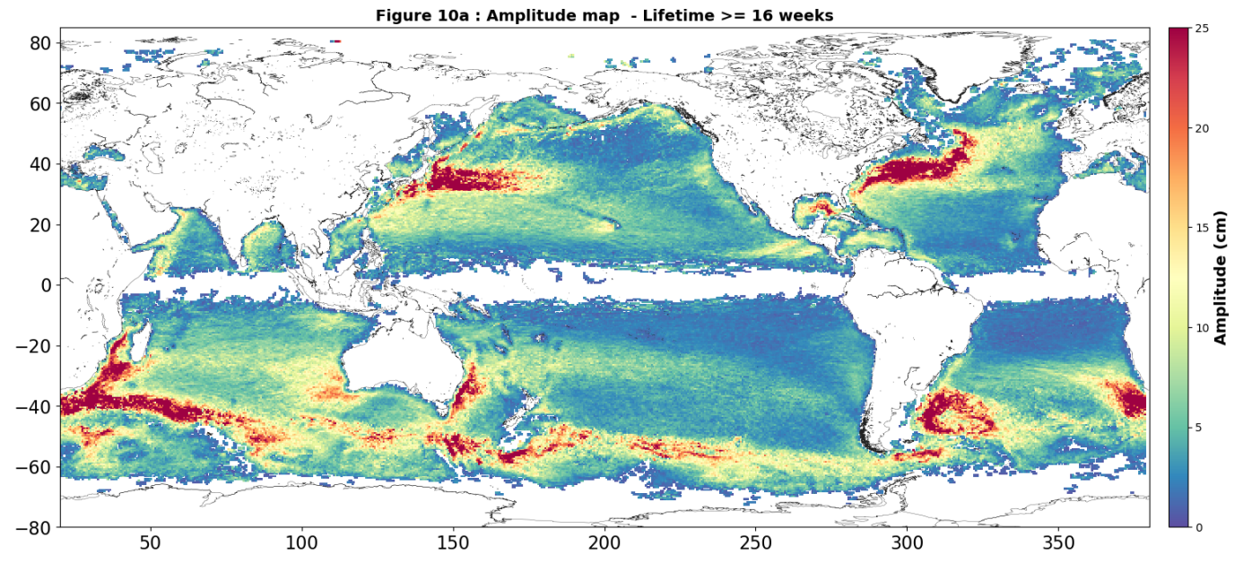
Eddies detected in Delayed-Time (DT) for the entire period [1993 - present]. Variables provided include day-by-day, and for one rotation type (Cyclonic/Anticyclonic) : - Center position (Longitude and latitude of the center of the best fit circle with the contour of maximum circum-average geostrophic speed); - Amplitude (|SSH(local_extremum) – SSH(outermost_contour)|); - Speed radius (Radius of the best fit circle with the contour of maximum circum-average geostrophic speed); - Speed average (Average geostrophic speed of the contour defining the speed radius); - Speed profile (Profile speed average values from effective contour inwards to smallest inner contour); - Effective contour (Largest contour of the detected eddy); - Speed contour (Contour of maximum circum-average geostrophic speed for the detected eddy).
-
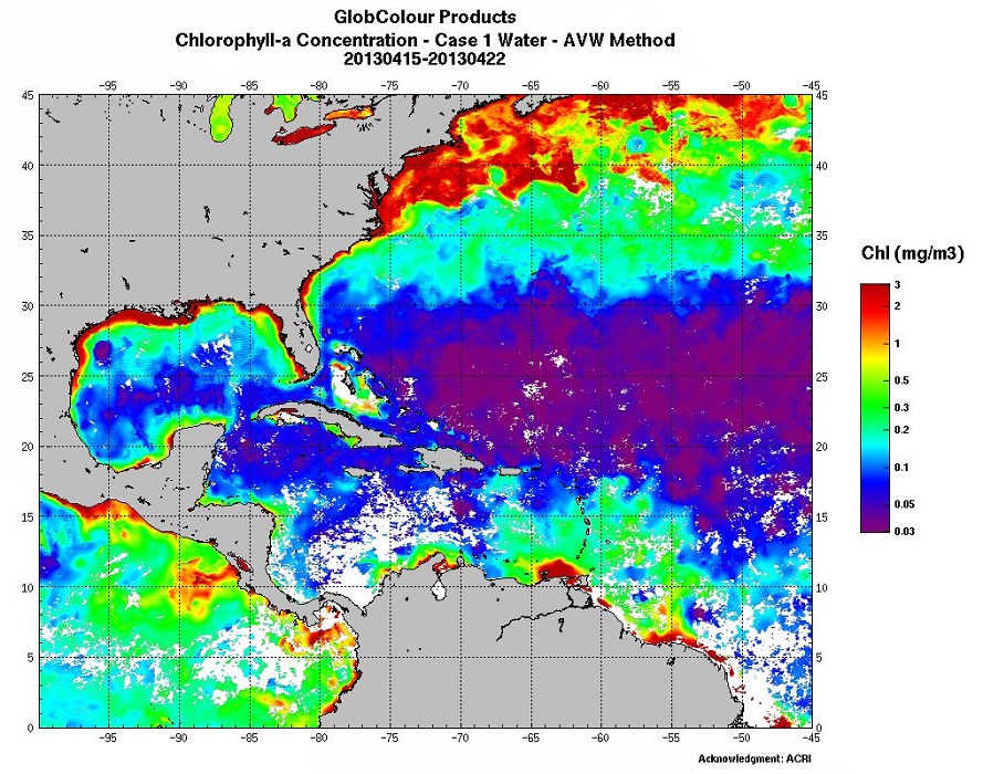
Biological parameters: Chlorophyll (several algorithms), Particulate Organic/Inorganic Carbon, Fluorescence…
-
The CTOH computes and distributes specific, coastal along-track sea level anomalies (SLA) using its X-TRACK processor over 23 regions, for all precise altimeter missions : Topex/Jason-1/Jason-2/Jason-3 (+Topex Interleaved orbit (TPN)/Jason-1 Interleaved orbit (J1N)), SARAL/AltiKa, Envisat, Geosat Follow On The CTOH computes and distributes specific, coastal along-track sea level anomalies (SLA) using its X-TRACK processor for all precise altimeter missions : Topex/Poseidon (TP), Jason-1 (J1) , Jason-1 interleaved (J1N), Topex/Poseidon interleaved (TPN), Jason-2, Geosat Follow on (GFO) and Envisat. X-TRACK cover today all the coastal oceans, with 23 new regions.
-
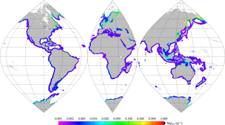
Monthly mean of backscattering coefficient (bbp) at 490nm (2002-2012) for coastal areas, at global scale, for MERIS sensor, with POLYMER atmospheric corrections. Ref: Loisel in prep.